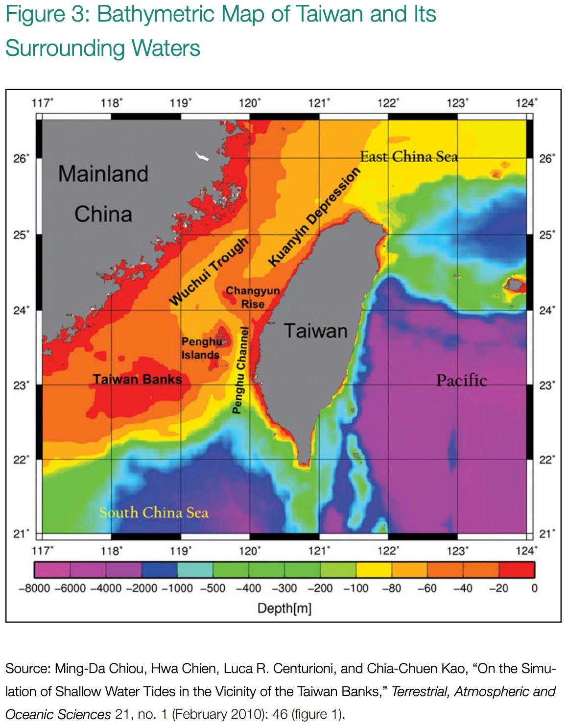
There it is.
As I mentioned on yesterday’s Midrats with Bryan Clark, the below graph from their latest report from Hudson is one of the first things anyone discussing a possible conflict with the People’s Republic of China must fully understand.
You cannot wish away, spin, or “offset” geography. The land component knows this better than anyone. The geography below the ocean is just as critical as that above it.
The geeks who like to soak in the details of ASW (guilty) know this well, but as they are usually kill-joys armed with “math” and “geography” - they are not all that popular during OPLAN development or revisions. When their Dungeons and Dragons partners are responsible for logistics, sustainment, and maintenance - their corner of the briefing room can be downright insufferable at the Q&A session following briefs by the DOD’s version of inspirational OceanGate alumni with their cool new ideas about fighting China they got after binge reading their latest military fiction novel on the way home from an industry sponsored conference in San Diego or Crystal City.
Yet … reality exists.
BEHOLD!
As we discussed in detail, the USN’s comparative advantage - CVN aside its crown jewel - is our submarine service.
We could go on for a few thousand words here, but before you jump in to the comments section I want you to look real hard at the graphic above, and then note these two details.
VA Class SSN are 377 feet long. Ohio Class SSGN are 560 feet long.
We can lob TLAM from blue to purple. Going in to the yellows to red for some anti-surface or SOF work? Unless you really are willing to accept a lot of risk with a nuclear powered and delicate platform…
A lot of very important people are putting a lot of faith in our submarine community to blunt any move across the straits to Taiwan from the Asian mainland.
I’m not sure they’ve seen this bottom contour chart or if they have, understand it. That doesn’t even begin to discuss the acoustic and weaponeering challenges here … which we probably don’t want to discuss on this net anyway. Let’s just say, “There’s some ‘there’ there.”


First time I've ever seen that Taiwan Strait bathymetric chart, and it is eye-opening. My inner-geologist tells me that in Pleistocene time, when sea levels were 300-400 feet lower than today, it was a land bridge. So bottom conditions are likely a bedrock erosional surface, now covered by relatively thin layers of silt, mud and other outwash sediment from the mainland and the island. I suspect that Chinese scholars have performed extremely thorough studies on acoustic propagation and bottom bounce. And along those lines, the "other side" can lay mines as well. No doubt, readers can envision what kinds of mines.
Lots of minable waters there between China and Taiwan. Submarines can deliver mines fairly covertly, albeit in limited numbers, but air/surface delivery would most likely be the key.